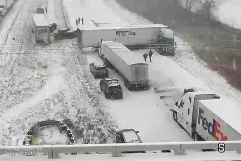
RELIANCE, S.D. — Winter storm warnings stretch from Colorado, into Wyoming, across South Dakota, Nebraska, Iowa, Minnesota, Wisconsin and Michigan. Many major highways are slick or covered with snow, including Interstate 90 across South Dakota.
According to the National Weather Service, a rapidly deepening area of low pressure over the Central High Plains will move northeastward to the Upper Great Lakes by Saturday morning. The low will move into Southeastern Canada by Saturday evening, as the associated front moves off the East Coast overnight Saturday.
The storm will produce snow over parts of the Northern/Central Rockies into parts of the Southwest on Friday morning. By Friday afternoon, heavy snow will develop over parts of the Northern/Central Plains into the Upper Mississippi Valley, expanding into parts of the Upper Great lakes by Friday evening.
The heavy snow will wind down over the Upper Great Lakes on Saturday into Sunday morning. The snow will result in reduced visibility and hazardous driving conditions.
Moreover, showers and thunderstorms will develop along and ahead of the cold front, mainly during the late afternoon into Saturday morning. Some of the thunderstorms will be severe.
Therefore, the SPC has issued an Enhanced Risk of severe thunderstorms over parts of the Middle/Lower Mississippi, Ohio, and Tennessee Valleys through Saturday morning. The hazards associated with these thunderstorms are frequent lightning, severe thunderstorm wind gusts, hail, and a few tornadoes.
Furthermore, there is a 10% or greater probability of EF2-EF5 over the region. The threat for severe thunderstorms decreases slightly on Saturday into Sunday morning. However, the SPC has issued a Slight Risk of severe thunderstorms over parts of the Ohio and Tennessee Valleys on Saturday into Sunday morning.
The hazards associated with these thunderstorms are frequent lightning, severe thunderstorm wind gusts, hail, and a few tornadoes.
In the meantime, the thunderstorms will contain areas of heavy rain. Therefore, the WPC has issued a Marginal Risk of excessive rainfall over parts of the Lower Mississippi, Ohio, and Tennessee Valleys through Saturday morning. The associated heavy rain will create localized areas of flash flooding, affecting areas that experience rapid runoff with heavy rain.
The Marginal Risk of excessive rainfall will move slightly south and eastward to include parts of the Southern Appalachians, Ohio/Tennessee Valleys into the Lower Mississippi Valley on Saturday into Sunday morning.
Likewise, the associated heavy rain will create localized areas of flash flooding, affecting areas that experience rapid runoff with heavy rain.
Meanwhile, onshore flow will aid in producing rain and higher elevation snow over the Pacific Northwest on Friday. On Saturday, a front will come onshore over the Northwest as rain, heavy at times, and higher elevation snow moves into Northern California. As a result, there is a Marginal Risk of excessive rainfall over parts of the Northwest into Northern California on Saturday into Sunday morning.
The associated heavy rain will create localized areas of flash flooding, affecting areas that experience rapid runoff with heavy rain. Additionally, heavy snow will develop over the Cascades through Sunday morning.
Check road conditions in areas affected by heavy winter weather through the weekend.
Tap here for Colorado
Tap here for Iowa
Tap here for Michigan
Tap here for Minnesota
Tap here for Nebraska
Tap here for South Dakota
Tap here for Wyoming
The Trucker News Staff produces engaging content for not only TheTrucker.com, but also The Trucker Newspaper, which has been serving the trucking industry for more than 30 years. With a focus on drivers, the Trucker News Staff aims to provide relevant, objective content pertaining to the trucking segment of the transportation industry. The Trucker News Staff is based in Little Rock, Arkansas.


There are storms that I can’t avoid during the week, but it sure is nice when I can be home and watch it happen.
Remember drivers that haste makes waste and that patience is a virtue. Slow down, leave ample distance, and do not get aggressive on snow and slick roads. Your dispatcher does not ride with you and if something happens on the road, they will never have your back, only your lunch.