


Updated 4 p.m. Central time (originally posted 1:44 p.m. Central time).
NEW ORLEANS — Hurricane Ida struck Cuba on Friday, August 27, as a rapidly intensifying storm that could speed across warm Gulf waters and slam into Louisiana as a Category 3 hurricane on Sunday, the National Hurricane Center warned.
Residents along Louisiana’s coast braced for Ida to bring destructive wind and rain on the exact date Hurricane Katrina devastated a large swath of the Gulf Coast exactly 16 years earlier. Capt. Ross Eichorn, a fishing guide on the coast about 70 miles southwest of New Orleans, said he fears warm Gulf waters will “make a monster” out of Ida.
“With a direct hit, ain’t no telling what’s going to be left — if anything,” Eichorn said. “Anybody that isn’t concerned has got something wrong with them.”
New Orleans Mayor LaToya Cantrell ordered the evacuation of everyone living outside the levee system that protects the area from flooding. She did not say how many people lived there, but urged residents with medical conditions and other special needs to get out early.
Officials warned they plan to close floodgates Saturday afternoon on two highways near New Orleans, increasing the sense of urgency for those planning to flee.
“Now is the time,” Cantrell said.
Officials decided against evacuating New Orleans hospitals. There’s little room for their patients elsewhere, with hospitals from Texas to Florida already reeling from a spike in coronavirus patients, said Dr. Jennifer Avengo, the city’s health director.
The White House said President Joe Biden and FEMA Administrator Deanne Criswell would discuss hurricane preparations Friday in a conference call with the governors of Louisiana, Alabama and Mississippi. White House press secretary Jen Psaki said FEMA plans to send nearly 150 medical personnel and almost 50 ambulances to the Gulf Coast to assist strained hospitals.
Ida became a hurricane with maximum winds of 75 mph Friday afternoon just before its first landfall on Cuba’s southern Isle of Youth. The Cuban government issued a hurricane warning for its westernmost provinces, where forecasters said as much as 20 inches of rain could fall in places, possibly unleashing deadly flash floods and mudslides.
An even greater danger will then begin over the Gulf, where forecasts were aligned in predicting Ida will strengthen very quickly into a major hurricane, reaching 120 mph before landfall in the Mississippi River delta late Sunday, the hurricane center said.
If that forecast holds true, Ida would hit on the 16th anniversary of Katrina’s landfall as a Category 3 storm with 125 mph (201 kph) winds near the riverside community of Buras in Plaquemines Parish, just down the Mississippi River from New Orleans.
Katrina is blamed for an estimated 1,800 deaths from the central Louisiana coast to around the Mississippi-Alabama state line. A massive storm surge scoured the shores and wiped houses off the map. In New Orleans, failures of federal levees led to catastrophic flooding. Water covered 80% of the city and many homes were swamped to the rooftops. Some victims drowned in their attics. The Superdome and New Orleans Convention Center became scenes of sweltering misery as tens of thousands were stranded without power or running water.
Memories of Katrina still haunt many who scrambled to prepare for Ida on Friday, lining up for groceries, gas and ice, as well as sandbags that the city was offering.
Traffic snarled at entrances to a New Orleans Costco, where dozens of cars were backed up at the gas pumps and shoppers wheeled out carts stacked with cases of bottled water and other essentials.
Retired police officer Wondell Smith, who worked on the police force when Katrina hit, said he and his family were planning to stay, but were also getting ready to head farther inland if the forecasts worsened. He spoke as he loaded water, bread and sandwich meat into his SUV.
“I know what that looks like,” Smith said, referring to the potential devastation. “This is my first time being home in 34 years of service. And I want to be prepared.”
Kickoff for Saturday’s preseason game between the Arizona Cardinals and the Saints at the Superdome was moved up seven hours to avoid the weather, to a noon Central Time start after consultation with city and federal officials and the National Weather Service.
“Ida certainly has the potential to be very bad,” said Brian McNoldy, a hurricane researcher at the University of Miami. “It will be moving quickly, so the trek across the Gulf from Cuba to Louisiana will only take one-and-a-half days.”
A hurricane watch for New Orleans and an emergency declaration for the state of Louisiana were declared. Category 3 hurricanes are capable of causing devastating damage.
“Unfortunately, all of Louisiana’s coastline is currently in the forecast cone” for the storm, said Gov. John Bel Edwards.
“By Saturday evening, everyone should be in the location where they intend to ride out the storm,” the governor added.
A hurricane watch was in effect from Cameron, Louisiana, to the Mississippi-Alabama border — including Lake Pontchartrain, Lake Maurepas and metropolitan New Orleans.
The mandatory evacuation outside New Orleans levees was prompted by storm surge predictions of 7 to 11 feet in the area, said Collin Arnold, the city’s director of homeland security and emergency preparedness.
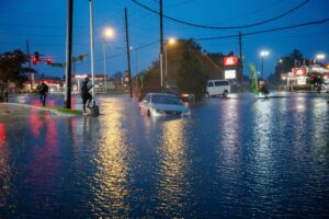
“Being east of this storm’s track is not ideal,” Arnold said. “We’re anticipating significant impacts, including tropical storm-force or stronger winds that could cause downed trees and prolonged power outages. Heavy rain in excess of 10 inches — now that’s over a day or two — could cause significant street flooding.”
By the time Ida reaches the central Gulf Coast Sunday, it could dump 8 to 16 inches of rain, with 20 inches in isolated areas, from southeast Louisiana to coastal Mississippi and Alabama through Monday morning.
By Kevin McGill and Janet McConnaughey. Associated Press contributors include Melinda Deslatte in Baton Rouge, Louisiana.; Jeff Martin in Marietta, Georgia; Darlene Superville in Washington; and Seth Borenstein in Kensington, Maryland.
The Associated Press is an independent global news organization dedicated to factual reporting. Founded in 1846, AP today remains the most trusted source of fast, accurate, unbiased news in all formats and the essential provider of the technology and services vital to the news business. The Trucker Media Group is subscriber of The Associated Press has been granted the license to use this content on TheTrucker.com and The Trucker newspaper in accordance with its Content License Agreement with The Associated Press.